| How do you read a topo map? |
|
||
|
By:
Osceola
Date:02-Sep-15
|
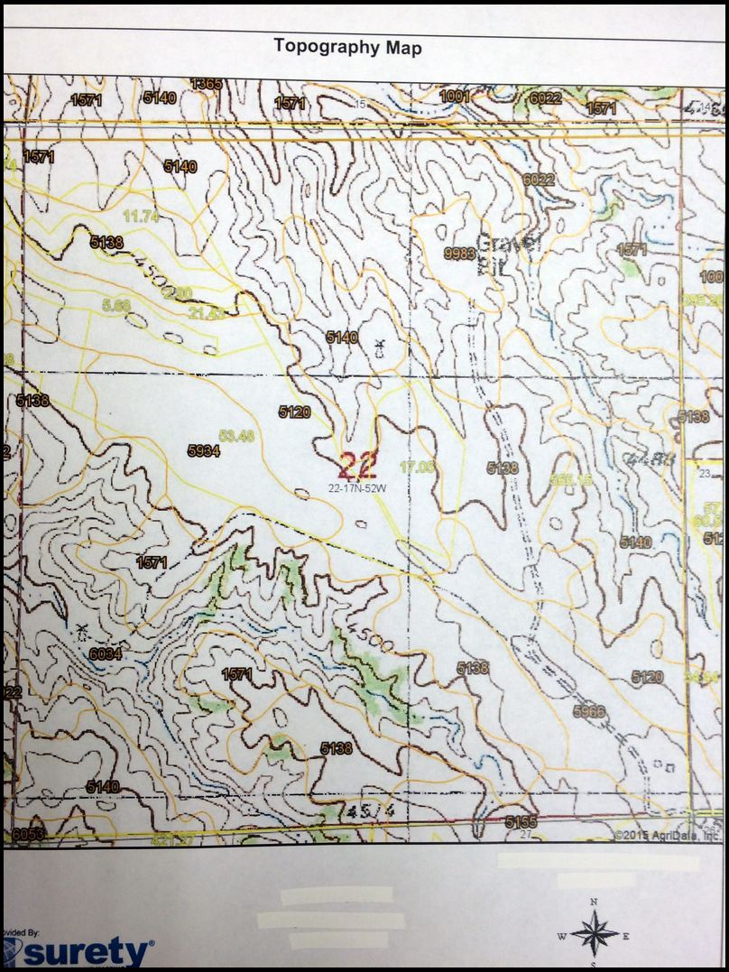
Tell me where you would put a stand on this 680 acres based on the topo map.
Explain as best you can what you are seeing from the topo that indicates it is a good stand location.
An aerial view is also provided. Winds are predominately from the Southwest and Northwest. Access point is in the southeast corner of the property.
I have never hunted the property but plan to this fall. Currently, I have 5 stands up. The property is 4 1/2 hours away from where I live so scouting in the evenings is not something I can do on a regular basis.
|
By:
Osceola
Date:02-Sep-15
|
|
By:
Osceola
Date:02-Sep-15
|
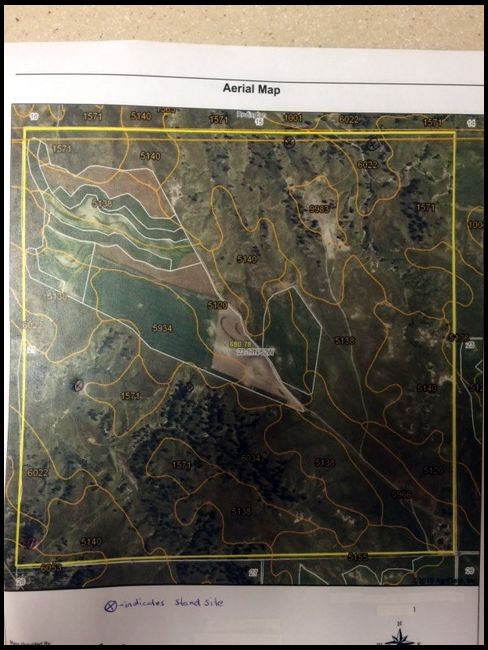
Here is aerial view
|
By:
Two Feathers
Date:02-Sep-15
|
without out feet on the ground I would be hard pressed to tell you where to put a stand. From your map and photo the first place I would check out is the southwest quarter. Looks like it holds cover, water and nearby food.
|
By:
Will
Date:03-Sep-15
|
Ditto two feathers. There are some ridge junctions/saddles down there with good looking prospects. While focused on white tails, the book "Mapping Trophy Bucks" would really help. It's a real easy read, and covers all the features you can see on a topo and how they relate to game movement. Worth the 20~ bucks for sure.
Will
|
By:
KJC
Date:03-Sep-15
|
Just above and to the left of 5138.
|
By:
Osceola
Date:03-Sep-15
|
It is hard to see from the aerial map, put I do have a stand in the SW corner. Actually heavy trail usage about 3/4 the side of the hill.
|
By:
Osceola
Date:03-Sep-15
|
If you are talking about the 5138 in the bottom part and middle of the page, that is actually the next spot I was going to walk/scout. If I read the map correctly, there are gentle slopes that make for easier walking path for the animals.
In reading maps, I look for a bunch of lines close together (steep incline) that will funnel movement either above or below that area. I also look for areas that have "v" shaped lines pointing toward an upside down "v" shape lines indicating a saddle or funnel. Any other clues to look for.
|
By:
RD in WI
Date:04-Sep-15
|
If I was hunting the property and had no familiarity with it, I would hunt the saddle in the north-central part of the map.
A saddle is the low ground between two hilltops. The hilltops are depicted by small closed circles formed by the contour lines on the map and the saddle is space between them.
My mom found an awesome place to hunt in Minnesota and when we looked at the topographical map, it was obvious how the terrain was forcing the deer past her stand. Looking at the terrain depicted by the topographical map, I didn't notice anything like what my mom had found.
Best of luck
|
By:
gobbler
Date:04-Sep-15
|
As aside note, I've run into a couple of younger hunters that didn't know how to read maps or topo maps. They grew up with GPS and never read actual paper maps.
|
By:
willliamtell
Date:05-Sep-15
|
Where's the food, where's the heaviest cover, now where's low spots between the two? If the wind is coming from the west (left side), you want to get on the downwind (right) side of it. Without knowing a lot of what really counts, I'd guess and say there are some northeast-southwest drainage fingers in the mid-lower part of the area extending towards the flatter (crop?) areas. You can tell so much more by actually finding trails and sign. Are we talking whitetails or mulies? Muleys might be in the more grassy open northerly areas? If you can get to the property but don't have a lot of time to sit and glass, a few trail cams are a worthy investment.
|
Date:05-Sep-15
|
I would check out the draw around 6034, between the two 1571's. Can't tell much about the pic. not sure if there are any trees to hunt out of.
|
By:
Osceola
Date:05-Sep-15
|
I appreciate all the input.
Landshark: I think the draw around 634, between the two 1,571 is major travel area as the deer travel to the south east to the crop fields.
RD in WI: I actually have a stand in the draw where you speak. It is closer to the northern boundary in one of the few big trees there.
|
By:
Bou'bound
Date:06-Sep-15
|
I'm with you I am shark launcher but would maybe move about 150 yards to the north east depending on prevailing wind direction